Howdy! It's been a while since my last post - I've had some concerned readers email recently to check in on me - I've been busy! One humongous project I had been working on for the past 6 or 8 months is the book Coal Dust, Rust & Saw Dust - it was finished at the end of February. Coal Dust, Rust & Saw Dust is a collection of essays and songs written by my good friend, musician, historic interpreter and teacher, Van Wagner. The collection spans a number of subjects including the Pennsylvania frontier, coal mining, logging and log rafting, iron manufacturing, charcoal production and local life, accompanied by the lyrics of 28 of Van's original songs that follow the subjects of each section. There is a special tribute section to Danville, PA, Van's hometown.
There are a number of photos documenting Van's various pursuits throughout the book. Also included are several of my own photos from local ghost town areas like Fall Brook, Landrus, McIntyre and Masten, PA. I designed the layout as well as the wrap-around cover image, based on the log raft re-enactment that was performed by Van and his crew in 2003-2004.
The book is now available for sale! The cost is $20.00 and this includes the book (128 pages), plus 2 CD's with all the songs contained in the book! It's a wonderful book for an awesome price! You can order the book directly from Van on his website www.vanwagnermusic.com - or, you can order it directly from me if you're in the area of Mansfield, Blossburg or Wellsboro, PA and I'll deliver a signed copy to you personally - just email me - sarah [at] insanart.com. Otherwise, things on the Insan Art front are the same as usual. I'm busy researching local history and of course, I'm still working on Landrus projects - the website is being built, very slowly. I recently laid out a trail that makes a hiking loop up the old inclined plane to the mines and then back down into the center of town. Please email me if you're interested in taking a guided hike.
I recently went out to Klondike, PA and finally got some nice photos of the foundations up there. You can see them here in my photo gallery. I've been researching local iron furnaces and I recently found another one south of Ralston, PA that is absolutely amazing. It's almost like a castle or cathedral in the middle of the woods. This furnace south of Ralston is much more intact than the other furnace north of Ralston (even though it was apparently used more/longer than the north furnace). You can see my photos of the furnace south of Ralston here (the north photos are in the same parent album).
Finally, I've recently had a boost in excitement over my property here in Blossburg, PA. In some of my recent research, I found a photo of Blossburg from 1874 that shows my house! Now, I knew that my house was OLD - it's a one of those "salt box" type coal mine houses, and it is in pretty bad shape. We've got original lathe exposed in the upstairs, a bathroom (watercloset) floor that's about to cave in, windows and doors over a hundred years old and virtually no heat or insulation. The deed lists this house as 1900, as is common with houses built before 1900. With this photo, I can now date it to at least 1874. This weekend, my husband took apart our old kitchen door to repair the latch and the latch plate had a date of 1871! What makes me most interested in these recent developments is the fact that we have an old outhouse hole on our property - this hole COULD date back as far as 1840! I now have an archaelogical dig site right in my back yard! I'll keep you posted with what I find in there as it gets excavated!
Tuesday, March 31, 2009
Coal Dust, Rust & Saw Dust (and more!)
Monday, May 19, 2008
1st Blossburg Geocache Event!
Hey Geocachers! I just wanted to let you all know that I've put together a small geocache event for Blossburg VIBE and it will be starting this Friday, May 23, 2008.
You may or may not know, the Blossburg State Coal Festival is this weekend (actually starting on Wednesday) and Blossburg VIBE wanted to try something fun and original to coincide with the festival.
And...the 1st Blossburg, PA Geocache Hunt featuring historic locations around Blossburg was born!
This is our first geocache event and we have only 3 caches, just to kind of test the waters. If things go smoothly, we hope to do another, larger event in the fall that would include locations in Blossburg, as well as Fallbrook and Landrus.
If you're not interested yet, we also have a few prizes to offer from some great sponsors! Wild Asaph Outfitters (Wellsboro, PA) has donated gift certificates, coupons and free rental tickets, Angelina's Pizza (Blossburg, PA) has donated gift certificates and Blossburg VIBE has furnished their awesome personalized water bottles - each cache will be contained in one of these bottles, while there will be a second bottle attached as a prize! (I will also be randomly placing more "prize" bottles on the caches after Memorial Day weekend/the other prizes are gone).
So, get on over to Blossburg for some geocaching and the State Coal Festival. For more information on the geocaching and coordinates, please visit:
http://www.blossburg.org/geocache
New Forest Sign Vandalism
 (please click on image to see it larger!)
Landrus is no stranger to sign vandalism (or other vandalism) - see my previous post about this other sign at Landrus.
This is the latest. I was out doing some maintenance on my portion of the Mid State Trail and taking some GPS readings on foundations when I found this sign ripped out of the ground. It
 marks (or marked) the split on the old rail grade between the Mid State Trail and the road up to the former location of the Landrus mines.
As I came upon it from down the trail it looked like a tree had fallen on the sign. On further close inspection however, it has clearly been pulled out of the ground (unless, it just happened to fall over due to the moisture in the ground, but I, doubt it...). Close
 views of the hole (below, left) and sign (above, right) both how they were found. I managed to stand the sign up and prop it up on a tree between the split in the trail, so if you're out there on the trail, you'll know where you're going...
Sunday, May 18, 2008
Beaver Fever!
 Sometime between late last fall and early this spring, beaver(s) have moved in to Landrus. Now, I have heard and read plenty of stories about beaver from the old days of town, but never in my 6 odd years at Landrus have I seen so much beaver activity!
The beavers have chewed down a large number of small trees as far upstream as the waterfall about my baptismal hole. There is a HUGE new network of beaver trails, some I will certainly use as part of my trail system, but overall their whole setup is just a bit excessive. I was impressed, yet worried when I saw that they had gobbled up the tops of every single briar between the falls and their mound.
 I'm also not too sure about their choice of location for their damn/home/mound thingee. It's right at the mouth of a very narrow section with small rapids. So far, it is only extending about a third of the way into the creek, but I'm watching it! The photo at the top was taken about 2 months ago. The other photo of the same location below (with my husband) was taken a week ago and the mound is clearly growing. (the other photo in the middle shows the gouged "trail" to the mound on the creek bank)
Sunday, March 16, 2008
Aerial Photography, Ghost Towns and the Internet
When it comes to ghost town hunting, there never seems to be a good way to "get the big picture" of something you're researching - especially when you're at the location, face to face with crumbling structures surrounded by grown in surroundings. It can take days of hiking and keen observations to actually "get the big picture" and start to make sense of ruins and remains.
The internet can give you a HUGE boost in that "big picture" department. There are a number aerial map interfaces and archives available online, but none that is so all-inclusive and user-friendly as Google Earth.

Click the photos to see larger!
While Google Earth has always been really great, it just got even better for those of us in Pennsylvania.
Maybe some of you had tried Google Earth before for PA areas and were disappointed by the lack of detail available, like I was. For areas around me in Tioga County, the amount you could zoom in before it got fuzzy was fairly pathetic.
That is all different now! PA DCNR just recently integrated their updated aerial photo archive into Google Earth and the difference is amazing! You really have to check it out for yourself (especially if you're a ghost town enthusiast), but, I've included these examples here to give you an idea of the kind of detail you can get.
The top photo is of what I like to call "downtown Landrus" - it's the "four corners" type spot where the stone monument stands. You can also see the creek quite nicely, the little waterfall is the location of the old log-jam dam.
You'll notice at the four corners that there are two vehicles and just below and to the left of the vehicles, a smaller rigid shadow - that is the stone monument. But what about those vehicles?
(sidenote: if you look in my driveway back in Blossburg in the aerial photos, there are no cars in the driveway)
As I zoomed in on this spot initially, I realized that the vehicle parked next to the monument is none other than my Jeep!! Either that, or it's someone else with a white Jeep with black hardtop that parks in my parking spot!
Have fun! I have another great vintage aerial photo resource, but I'll save that for another day...
Full Landrus Website
SOON! (later than sooner) But, soon there will be a complete Landrus website! I'm just working on the full layout and getting together the exact content, but the full Landrus, PA website is in the works!
The website will be a hub for information on both Landrus the town AND Landrus the man - Henry Jackson Landrus that is. H.J. Landrus was a foreman with Bloss Coal Company whom the town was named after. He never lived there himself but he is forever connected by the namesake.
I frequently receive inquiries from folks asking about both Landrus situations, so I felt it is only appropriate to feature both on the website.
I hope to have the site up by May. We'll see how things go!
Sunday, January 06, 2008
Please Pray for Meredith Emerson!
(UPDATE: Monday, January 7, 2008, 9:45pm. I just read that authorities have found the body Meredith Emerson. My prayers go out to her family and friends - you may send a note to her family here.)
(I apologize to those who read both my blogs, this is a repeat from my other blog, but I think it is very important and also relevant, thanks!)
I've been watching this story ever since New Years day - Meredith Emerson, 24, and her dog Ella have been missing since then when they went out for a hike on an Appalachian connector trail in Georgia - link to the story, link to the site: http://www.helpfindmeredith.com/
This morning's news on the story wasn't very positive, but I still wish to ask for you all to pray for a miracle that she might be found alive! Please keep the searchers and her family in your prayers as well.
I immediately took notice of this story since it reminded me of an encounter I had 2 or 3 years ago with a strange man at one of my favorite recreation spots, Landrus, PA (link to post about it). Since this occurred, I am truly afraid to go enjoy Landrus alone and I have a hard time going outdoors by myself without some kind of weapon or pepper spray (pepper spray is good for bears, too!).
So, please keep these folks in your thoughts and prayers! Ladies, please be careful when you're out by yourselves or go out with a buddy!!!
Thursday, October 11, 2007
'Tis the Season...
Another season of exploring is almost upon us! If it would only get cold outside and frost (did I actually admit that I DO want that? I'll be bitching about the cold in another couple months!)
Despite the warm temps and DRY, snake-friendly weather, I have already been getting into the bushwhacking mode. I've got a few Landrus based goals I'm working on for the cold winter months:
- Label my Landrus Photos in the Photo Gallery - Yes, I know, long time coming! I apologize for not having this done yet, life is hectic! Part of the labeling process is to start including location in labels/descriptions. As the official Landrus map is yet to come (see next goal) I will be labeling the locations of items in the photos with general locations only, not only due to difficulty describing the actual locations (without GPS coordinates), but also because I hesitate to disclose the exact locations of some of these spots! It's not as if I'm hiding anything - these spots are actually easy to find and just require a keen eye and little extra off-road looking (and maybe creek crossing!)
So for now, I'll be labeling the photos in regards to their side of the creek and whether they fall to the east or west of the "four corners" on Landrus Road (this is where the stone marker is located). Sure, still a bit vague, but it will give some idea of general location. So here's what it will look like:
"N" or "S" - North of Babb Creek or South of Babb Creek.
"E" or "W" - East of the marker or West of the marker.
- Start working on a correctly scaled map - Now that I might have a free moment to learn how to use my GPS more in-depth, I want to start mapping the town to scale. My goal is to create a map that I can use to number/label the foundations/remains and pinpoint locations of road and rail grades, bridges, trails, etc. I'm not sure how long this endeavor will take, it really depends on how the weather is this winter.
- Create a full on Landrus Website! - Not that I don't love Blogger, but I really need a more multi-faceted output for all this Landrus stuff! Conveniently, I'm in the middle of housekeeping and remodeling for all my sites, so I hope to work on the Landrus Site when I'm done redesigning the Insan Art website. I hope to also include a section for other local ghost towns, possibly with some guest content!
- Research creating a non-profit organization for Landrus - Yes, that's right, Landrus Historical Foundation baby! I'm VERY interested in creating a non-profit committed to preserving and promoting the history and legacy of Landrus, PA. More to come on that...if you have any interest, please email me.
Check back soon, I should have a lot going on here in the next few months!
Thursday, September 06, 2007
Forgotten Pennsylvania Blog
Hi Everyone, just thought I'd share this link to some folks who are into the PA ghost town thing as well.....
http://forgottenpa.blogspot.com/
I've added the link to my links section, they were nice enough to do a little write up on other PA ghost town sites, including mine....
I'm itching to create a full Landrus website soon.....also working on the first steps to creating an accurately scaled map of the town.....
Monday, June 11, 2007
Baptism at Landrus, New Environmental Sculptures

On the afternoon of June 3, I was baptized in Babb Creek at Landrus. This event was a culmination of a couple of projects and a ton of preparation, all in lieu of our wedding. For more information and photos, please read my entry about it on my Insan Art Blog.
Update: I made the local papers, no photos or mention of my art unfortunately.
http://www.sungazette.com/religion/articles.asp?articleID=19418
Monday, April 16, 2007
Calling Mr. Comment...
Hey, I'm trying to reach the person who keeps leaving comments on my Landrus photo gallery about the lack of descriptions. Just to let you know, I have 1000's of photos that I am trying to manage. I will label the ones online when I get to them. If you think online galleries are all I do all day, guess again. I am in the middle of planning a HUMONGOUS wedding, and frankly, that is taking up ALL of my time. (i'm barely even getting to Landrus lately, except to work on my baptism/environmental sculpture #3&4 projects.)
So, if you want an answer to your comments, leave me an email address next time, or just email me with a reference to which photo (the number) you're talking about.
Thanks.
Monday, March 26, 2007
Landrus Photos Link - Final!
Ok, i believe that this should be the final link for my Landrus photos (yes, it changed since it came down and went back up, lol!)
http://pictures.insanart.com/v/ghosttowns/landrus/
.....and be sure to check out the rest of my photos, including some other ghost towns at:
http://pictures.insanart.com
Thursday, March 15, 2007
Landrus Fever!
AYE! I want to get to Landrus!!!
For those of you who had bookmarked my old Landrus photos page, the website had to get torn down and rebuilt from scratch - NOT TO FRET! it will be back at:
http://pictures.insanart.com
you'll find Landrus photos in the Ghost Towns sub-album (eventually when I get them back there - i'm working on it now since I had a request for them).
Back to Landrus soon!!! I must get down there and work on my Baptism/Environmental Sculpture project (more to come on that). Come on (real) spring thaw!
Monday, November 20, 2006
Landrus Old Timers Reunion?
I am seeking information about the gatherings that took place at Landrus after its closure. I've seen one newspaper article that decribes the Landrus Old Timers Reunion that took place in 1925, with 200 original Landrus inhabitants attending. This same article talks about plans for future reunions.
Have any information about these reunions? Pictures? Any Landrus information at all? Please email me: sarah@insanart.com
Wednesday, September 20, 2006
C'mon cold weather!
I'm waiting for the cold weather to really dive into the exploring again, but I have been out a bit. Investigated the possible location of Stone Mill, two "towns" west of Landrus. I'll have photos up as soon as humanly possible. I've been very busy working on a mural, check out my other blog for more info.
Wednesday, May 17, 2006
New Photos!
I have many new photos up on my Landrus Gallery. They were put up to accompany the paper I wrote recently for school on Landrus. Please check them out (link above).
Anyone interested in a tour/hike at Landrus, please email me at sarah@insanart.com.
There are many new developments in the exploration of the area. More to come, as always!
Monday, March 20, 2006
....so....much....to.....come!!!!!
I have a lot of new things to share......
......panoramas clutter my digital photo time at the moment, so as soon as i get those darn things finished and get my Cafepress store up and running, i'll have some new things to share! Check back soon!!!!!!
Friday, January 06, 2006
A school, two churches and some outhouses! Oh My!!
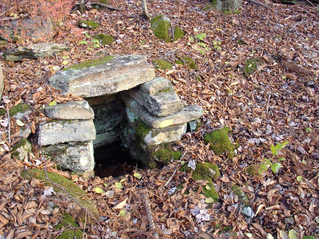
It must have been early November when i got the map of Landrus from Pete (thanks!). It's an old hand drawn kind of thing with no scale, but it made a lot of sense to me.... i copied it quickly in my sketchbook and anxiously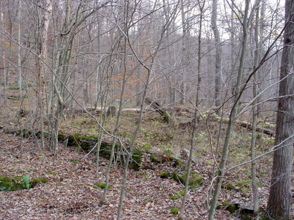 anticipated the next day when i would have the time to go to Landrus.
The landmark on the map that caught my eye was a spring - not because i knew it, because i didn't know it! I don't want to give alot of information about its location, but i see it everytime i drive by now that i know where it is. (top photo)
From the spring, the map led me to most everything on the south side of Babb Creek that i was previously unfamiliar with including the school, the Yankee Church (middle photo) and several house foundations. I also came upon another very nice spring house, some outhouse pits(bottom photo) and a foundation with "indoor plumbing".
The only major map landmark on the south side of the creek that i have not been able to locate/identify is the Swedish Lutheran Church. I need to go back and look again, but it doesn't appear to be where the map says it is located. It shows a distance of 800 feet between the school and the church. I measured from what i believe to be the school and didn't find much! It's possible that i think the wrong foundation is the school. I did come across some spots that could have been the church - the foundation just may not be as intact as the rest.
The map also answered a few of the questions we'd always had about Landrus - it identifies the concrete stand-like thing next to the road at Landrus as the Rail Road water tank tower. The large, raised plot near this that is used heavily as a camp these days is apparently where the foremans house once stood. The half foundation that sits across the road from where the stone Landrus marker is today was the company store.
There is so much more to the town, more to come on the portions of town north of Landrus rd. and Babb Creek.
For more pictures, go to: http://pictures.insanart.com/landrus
Tuesday, October 04, 2005
Nickel Run - it's a jungle!
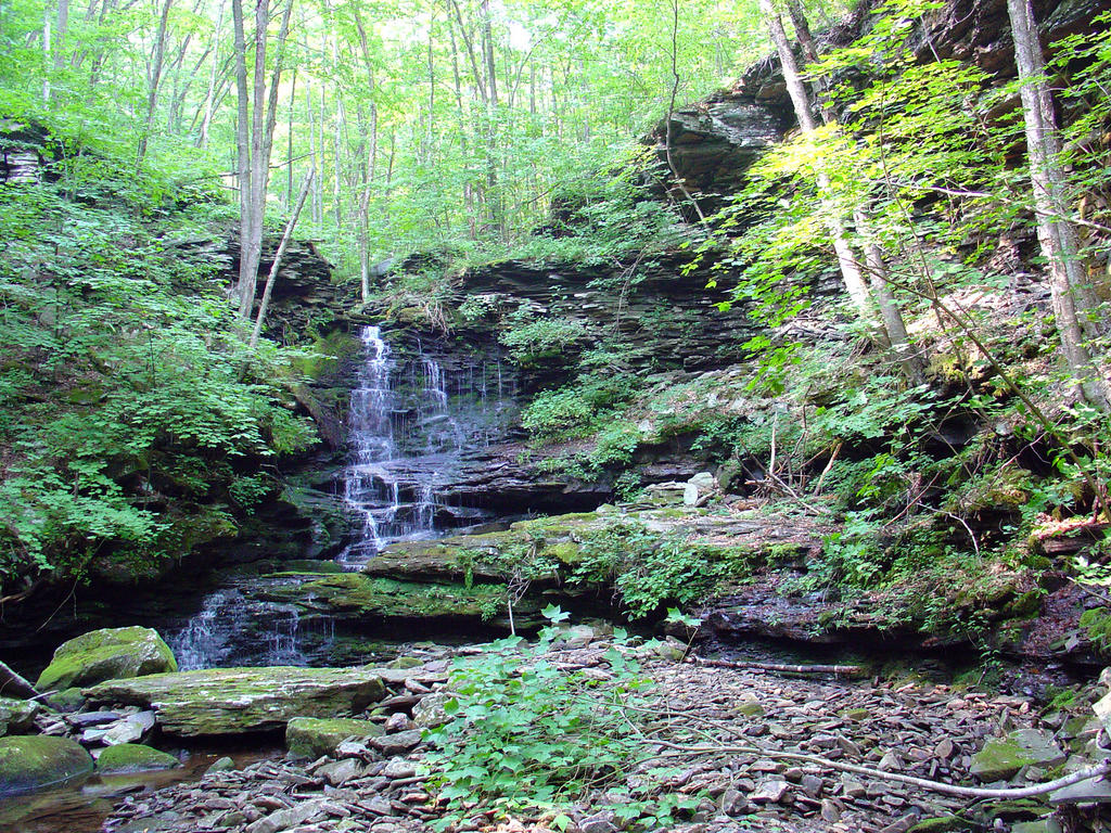
The falls on Nickel Run. Great little falls (it's not that small, i'm pretty sure it's actually taller than Sand Run falls). Watch for falling rocks, a portion of the outcrop/overhang below had fallen fairly recently.

(Nickel Run is a tributary of Babb Creek, entering just downstream/west of Landrus.)
My trail had a sign! (for about a week...)

I pull in to Landrus two or three weeks ago and to my suprise I found a spanking new State Forest sign marking the head of the trail I do my sculptures on. "BEAR RUN TRAIL".
Nice.
I took a picture thinking, "this would be great for the blog."
Glad I did, 'cause a week later when i came back it was gone! The pole is still there, but the part with words is gone. Oh well. It was nice while it lasted.
(actually, i've been meaning to email dcnr and see if maybe they took it down)
(UPDATE: as of 4/21 the sign has been replaced....yay again!)